Offering Advanced Drone Inspections, Progress Evaluations, Route Planning, Mapping, and More
Revolutionizing Energy Project Management
At Rise Above Services LLC, we revolutionize the way you manage, inspect, and plan your energy projects. Leveraging advanced drone technology, we deliver precise, efficient, and cost-effective solutions tailored to your needs.
What We Offer
Routing, Constructability, Boots on the Ground, Logistics, Search and Rescue, Gas Detection and Real Estate, Environmental Assessment
UAVs are used to quickly collect data, greatly reduce field costs, and flexibly generate a variety of surveying and mapping results to provide a basis for land development and remediation, environmental and disaster monitoring, hydrogeology, and urban planning.

Overview of Devices
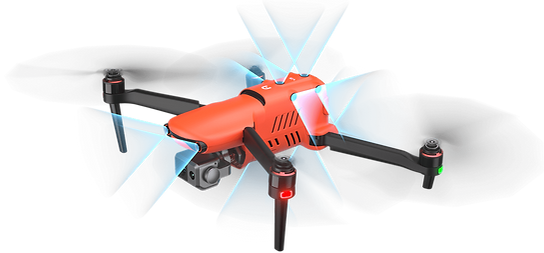
Broadcast live mission intelligence to other personnel in the operation for enhanced situational awareness and critical decision-making. The EVO II Dual 640T V3 is compatible with Live Deck 2, which offers multiport streaming to monitors and Wi-Fi support for multiple smartphones.
1080P Video Stream
Three Auto-Switch Bands
12 KM Transmission Range
IP43 Resistance

Centimeter-Level Positioning
The EVO II RTK Series V3 integrates an entirely new RTK module for 2022, which provides real-time centimeter-level positioning data in three minutes and supports Post-Processing Kinematic (PPK). The aircraft can record the original satellite observation data, camera exposure parameters, and more. The positioning system supports the RTK base station and NTRIP RTK network, which helps to achieve accurate and stable data acquisition in complex operation environments.
Why Choose Us
We utilize cutting-edge drone and thermal imaging technology for the most accurate assessments.
Our skilled professionals are dedicated to delivering top-quality services tailored to your needs.
We offer flexible solutions for cloud-based data delivery or hard copies.
Our drones provide quick, reliable insights that are crucial for time-sensitive operations like search and rescue and storm damage evaluations.
We support environmentally conscious energy management practices through thorough environmental assessments.
Explore More
Elevate your energy management projects with our cutting-edge drone technology and expert services. Explore how our comprehensive drone services at Rise Above Services LLC can enhance your operations' efficiency, safety, and sustainability.